Solihull reveals where 13,000 new homes could be built in the green belt
By Sam Greenway - Local Democracy Reporter 1st Oct 2026
The areas of the green belt in Solihull which would be used to build thousands of homes have been revealed in the draft local plan.
The 200 page plan outlines how Solihull Metropolitan Borough Council (SMBC) could develop up to 2043, and if adopted would act as a housing blueprint.
Solihull is under pressure to meet the government's target of building 8,500 new homes in the borough before 2029.
One of the policies in the plan is: "The council will identify sufficient land for at least 13,096 net additional homes, to ensure sufficient housing land supply to deliver 21,913 additional homes in the period 2026-2043."
The "broad locations" where 8,219 of homes would be built over this period was revealed prior to back-to-back meetings held on September 29.
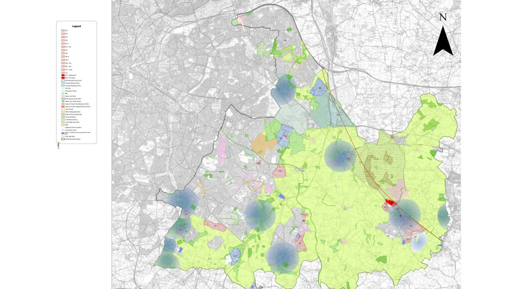
And a map showing the location was also included in council documents.
The broad locations, their label on the map and the capacity of homes they would take are:
- 'BC9' – Land at Phase 3 of the Balsall Common Relief Road – 1,100
- 'BC10' – Berkswell – 1,350
- BC11 – Tile Hill – 1,190
- BL4 – Shirley, Whitlocks End and Wythall Stations – 1,577
- HA3 – Hampton in Arden – 1,350
- KN3 – Dorridge – 814
- NS2 – Marston Green – 36
- SO3 – Widney Manor – 802
In a separate section there is a list of 'residential allocations' for 4,877 homes. This relates to allocations, carried forward from the council's previous 2020 local plan, which have not yet had a planning permission related to them. This list includes:
Download our Nub News App!
- It’s FREE and available now- Breaking news notifications
- Your Town in Your Pocket


- BC1 – Barratt's Farm, Balsall Common – 1,160
- BC3 – Windmill Lane/Kenilworth Road, Balsall Common – 132
- BC5 – Trevallion Stud, Balsall Common – 310
- BC6 – Lavender Hall Farm, Balsall Common – 92
- BL1- West of Dickens Heath – 536
- BL2 – South of Dog Kennel Lane (west), Blythe – 700
- BL3 – Whitlock's End Farm, Blythe – 450
- HA1 – Meriden Road, Hampton in Arden – 100
- HH1 – School Road, Hockley Heath – 100
- KN1 – Hampton Road, Knowle – 193
- KN2 – South of Knowle – 225
- ME1 – West of Meriden – 10
- SO1 – East of Solihull – 770
- SO2 – Moat Lane Depot, Solihull – 99
A recent change in national guidelines promotes development around well-connected railway stations. The draft plan says "an assessment on a station-by-station basis has been undertaken to identify the likely capacity that could come forward from sites within 1,000m of railway stations "- with this figure being 8,219 homes.
At the economic development, managed growth and skills scrutiny board meeting officer Mark Andrews, the council's head of planning, design and engagement services, said the policy had formed a "key part" of their work preparing the plan.
Cllr Sally Tomlinson, chairperson of the board, said: "Given this is relatively new building around stations, how are we going to ensure this is done in an organised fashion and gives us the opportunity to do the infrastructure around it?"
The officer replied if national rules are changed it would become a "default yes" for development around railway stations.
"We were very mindful if we didn't take seriously that as we developed the local plan, we could end up with a sort of double whammy of development proposals across the borough," he said.
"We have got a real opportunity in taking this approach to drive local influence."
Cllr Max McLoughlin said he wanted to ensure the local plan made it "explicitly clear that whilst this is how Solihull Council aims to arrive at the number the government has set – this does not release that land from the green belt.
"The reason that is important is so the planning committee retains some powers and developers don't strong-arm the council," he added.
Cllr McLoughlin put forward this as a recommendation which went on to be agreed by the scrutiny committee and cabinet.
The cabinet agreed to endorse the plan, and recommended the full council approve it at its next meeting scheduled to take place on October 6.
Download our Nub News App:
- It’s FREE and available now
- Breaking news notifications
- Your Town in Your Pocket
Share: